Wednesday, June 30, 2010

Day 10 - Boise to Mountain Home, ID

Today: 53 miles, 1990 feet of climb
Cumulative: 702 miles, 33012 feet of climb


It was great to have a day off yesterday. The batteries are recharged and everyone was anxious to again head east this morning.

The bike path along the Boise River

Boise is a very friendly biking city. There are bike lanes on many streets, and bike paths in Julia Davis Park and on both sides of the Boise River. So many paths it would be easy to get lost here. There is also a greenbelt path that heads southeast along the river.


Bronco Stadium.  They are about to install new blue turf for the 2010 football season.

The bike path system here puts the Atlanta area to shame. Then, there are bike racks through the downtown area, which is loaded with restaurants and many folks go by bike. Last night several of us walked to an ale house for local beer and hamburgers, salads, or steak.

Yesterday during the day, I went for a short ride on the river bike paths, just to get the muscles warmed up. Being a Boise State football fan since they pulled off that 43-42 upset of Oklahoma in the 2007 Fiesta Bowl, I also had to visit Bronco Stadium. Remember the hook and lateral play on fourth down and eighteen yards to go, from midfield, with 18 second to play? Or the Statue of Liberty play for the winning two point conversion? No one was allowed on the football field, since they are about to replace the blue synthetic turf, but I did go through the stands, the outdoor patio area, and also visit the Humanitarian Hall Of Fame. Tied in with the Humanitarian Bowl game each year, this is a hall of fame for athletes who have also made other major contributions to society. Dikembe Mutumbo, Steve Smith, Dale Murphy, Mary Lou Retton, Harmon Killebrew, Tom Landry, Kirby Puckett, and Julius Erving are just a few of the athletes enshrined here. Boise State is one of the least expensive universities to attend in the west.


Riding on the freeway today

This morning, the weather was fantastic. A bit cool at the start, but the sun warmed us up as we hit the roads. The course was easterly along the Boise River bike paths and greenbelt, then a few streets until we reached I-84. We had a kicking tailwind when we got on the freeway. We stayed between 25 and 32 miles per hour for the eleven miles we were on the interstate. At one point I looked at my Garmin and was at 31.7mph, 90rpms, and could have easily used two more clicks on the gears to go faster. I have never had an exhilarating fast ride like that before.

After we left the freeway

After exiting the freeway we took some roads into the middle of nowhere, as you can see from the photos, before eventually heading back towards the interstate and the town of Mountain Home. It was a short and fast ride, averaging 19.2 miles per hour from the hotel to town. That included a few leisurely early miles on the bike paths too.

On the way to Mountain Home

Tomorrow will be a more serious day. 97 miles to Twin Falls. I hope the tailwind is with us again.

Tuesday, June 29, 2010

Day 9 - Boise, ID

The 2010 ABB North riders

This was a rest day in Boise. No riding today.

I have been asked what a typical day is like. My alarm clock gets me up 45 minutes before I have to load my luggage on the truck. This is generally between 5:00 and 5:30AM. Up, shower, and make a final pack. Put your bags on the truck and initial the sign in sheet so the tour knows you have left your room. A typical sign in sheet is shown here.

We have to sign in several times a day

Breakfast is 15 minutes after luggage load. We initial another sign in sheet at breakfast. Then, back to the room to get the bike and helmet and hit the road. The first hour on the road is always the best. Dawn is breaking, it is cool and quiet. You are feeling fresh after a good nights sleep. We have a “turn sheet “ that shows the turns each rider needs to make on the route for the day, since the course is not signed or painted like normal organized rides. A sample turn sheet is shown here.

This is what the turn sheets look like

A SAG (support and gear) stop is set up every 25 miles, where you can refill your bottles with fluids, grab some fruit, nuts or cookies and continue on. You again initial a sign in sheet at each SAG, so the tour knows you have reached that point. This is what the food looks like at a SAG stop.

This is available to us at each SAG stop
We are responsible for our own lunch and there may be a gap in the SAG coverage around lunchtime since there are only three vehicles (the luggage truck, the mechanic van, and the second support van). There is no hurry any day, since our hotel rooms may not be ready if we arrive early. Plus, early finishers get to unload the luggage truck. When we get to the hotel, we again initial a sign in sheet, get our room keys, retrieve our luggage, and go to our rooms to freshen up. The rest of the afternoon is at our leisure; a nap, laundry, blog updating, or bike maintenance. Dinner is generally around 6PM, a group affair (where yes, we initial another sign in sheet), and afterwards we have “route rap” which is a review of the next day’s ride and distribution of the next day’s turn sheet. Then, the evening is at our leisure, which usually means an early bed time. I brought a paperback book with me and haven’t read a page yet.

A typical RAP meeting. Mike opens and then Karen reviews tomorrow's route

The tour staff is comprised of six people. Mike Munk is the tour director and his wife Barbara heads up the logistics and drives the luggage truck. In the picture above, Mike is giving us information for the next ride at the route rap meeting. We have a mechanic (Jim), and three other support staff (Jeff, Debbie, and Karen) who support the SAG stops, or ride sweep so that no one is left behind. Each gets to ride part of the course every other day. They are very organized and the tour is exactly as it was advertised.

Monday, June 28, 2010

Day 8 - Ontario, OR to Boise, ID

Today: 65 miles, 1969 feet of climb
Cumulative: 649 miles, 31022 feet of climb


Oregon was a wide state but we're finally through with it

It was a warm day today. No windbreakers, vests, or arm warmers were needed, select for a few riders, and it warmed into the 90’s by the time we got to the hotel in Boise. It reached over 100 degrees in the afternoon here.

The route today had many left and right turns and our five person group (I have a hard time typing “The Thoroughbreds”) managed to make all of them correctly, with the help of the two strategically placed America By Bicycle vans. The total climb was not much to talk about, but there were many small hills as opposed to the large continuous climbs we’d been doing earlier in the week. Today reminded me of the back roads in the Cartecay area (Parker Road in particular). Rolling hills, the smell of dirt, hay, and cattle farms, while riding on sun baked roads. We took back roads south and then east into the Boise suburbs where bike paths took us to our destination. The housing industry must have been hit here too. There were a few subdivisions with roads and sidewalks but no homes. Very nice houses but I wonder what it is like to live here in the winter.

Irrigated farms everywhere

Right out of the hotel we crossed into Idaho. So our first state is finished. With nine total days of riding behind us, and two thirds of the way towards one thousand miles ridden, it is a bit daunting to realize there are still over three thousand miles remaining until we reach the Atlantic Ocean. I calculate 18% of the miles and 28% of the climbing complete so far.

Todd, coming over a hill

Tomorrow is a well needed and welcome rest day in Boise. Several people are nursing small aches and pains, and the layover day will do them good. I’m a bit tired myself, but the legs are holding out so far. This completes the first of six segments of the tour and we said goodbye to two riders who are only going this far. No new riders are joining us until Casper on July 10.

Jeff and Mark have Canadian roots

Someone asked my wife Karen, if I am eating well. I had hoped to lose a few pounds while riding and it started well. The first few days I didn’t have dessert and helped myself to the salad bar and fruit as much as I could. Then there was yesterday. An ice cream sandwich from a convenience store at 9:30. A trip to Dairy Queen for a hamburger and hot fudge sundae for lunch. And dinner at The Sizzler, which has a great ice cream bar if you are interested. Ice cream three times in one day. I can’t be doing this. Today I declared a “no ice cream” day.

Tonight we had a catered barbecue chicken dinner and saw the new Tom Cruise, Cameron Diaz movie which was OK. We are on our own tomorrow. I’ll be sleeping in and think about tomorrow in the morning.

Sunday, June 27, 2010

Day 7 - Baker City to Ontario, OR

Today: 84 miles, 2251 feet of climb
Cumulative: 584 miles, 29503 feet of climb


Where were we this morning? Oh yeah, Baker City. The days are starting to blur together.

Remember when you were a kid? That day during summer vacation when you had nothing to do, got on your bike, and cycled somewhere far and new? It is like that every day for me.

A morning panoramic view

It was another very nice ride today. A cool start with wind vest and arm warmers again, but it warmed into the 80’s by the time we finished. This was my type of day at the end, nice and hot. Real BRAG weather.

Just getting started. Still a long way to Ontario.

Today’s route started through downtown Baker City and went south on old Route 30. The Oregon Trail ran through this area, from the Snake River through the Burnt River Canyon and was the emigrant route to the west coast from 1843 to the mid 1860’s. The trail at that time was extremely bad by written accounts of it, because the mountains close right down on the river. It must have been very hard to get through this area on the way west. The Burnt River takes its name from the blackened and burnt appearance of the hills and mountains on either side. Twice, we had to get on I-84, which is permitted out here, because there are no other roads to get east, the old road through the canyons being replaced by the interstate highway. The day concluded with a turn onto Route 201, which took us along the Snake River to Ontario. The land is arid here, except for the crops that grown where it the land is irrigated. Our first SAG was at a rest stop along the Interstate with shade and picnic tables. Jean from Boise, who did this ride two years ago, brought us homemade brownies and strawberries. Our second SAG stop was on the banks of the Snake River, where I got to talk to a few of the local residents who were sitting by the shore. Most folks come here to fish.


One step closer

The same gang of five, also referred to (probably disparagingly) as “The Thoroughbreds”, rode together today, picking up Bill and Dan towards the end. It was a much easier day because there was a lot of downhill and not much climbing. Just one hill of note.

First view of the Snake River

The region’s primary industry is potatoes (duh), sugar beets, and onions. I don’t know much about farming, but we smelled the onions growing in the fields on the ride into town this afternoon. And the dead skunk too. Ontario is on the border with Idaho, and retail is big on this side of the Snake, since Oregon has no sales tax. It will be one state down and nine states and a Canadian Provence to go, tomorrow morning when we cross the river.

Late in the ride today

Thanks to my cousin John, who sent me mail today with some useful information about the Ontario area. Also thanks to Gary M. for the encouraging words.

Saturday, June 26, 2010

Day 6 - John Day to Baker City, OR

Today: 84 miles, 5377 feet of climb
Cumulative: 501 miles, 26802 feet of climb


After yesterday’s 116 miles, today was a tough day for me. I was dragging towards the end of the ride. 84 miles on my Garmin, with three significant climbs, and a headwind in the afternoon. This was mitigated by blackberry cobbler a la mode at 8:30 AM, a sandwich and banana for lunch at 58 miles, and a vanilla milkshake near the finish.

Covered wagon at SAG1 on the way up the first climb

It was the usual early morning luggage load at 5:20, and breakfast at 5:30, since it was going to be another long day for everyone. I was happy to again ride with Mark, Dave, Mark, and Jeff. We started after most riders had left John Day and cycled up through most of the field by day’s end. The weather was cool at the start. Arm warmers and a vest or windbreaker were the order of the morning. By afternoon it was hot though. Sunny skies, no clouds. The route today was not difficult to follow. Just one left turn after 28 miles, finally leaving US26, which we have mostly been following since Portland.

Jeff and Dave on the first climb


There was not much flat ground today. The first climb over Dixie Mountain was 21 miles followed by a cold seven mile descent in shade. After blackberry cobbler, we started up Tipton Mountain, an eight mile climb followed by a seven mile descent. Then, we immediately started up Snall Mountain, a seven mile climb followed by a four mile descent. The climbs got up to about 7% grade in places. After lunch, the rest of the day was supposed to be slightly downhill, but it didn’t seem that way because of the headwind and hot sun. Day five’s ride into John Day probably had something to do with the difficulty also.


Summit of the second of three big climbs today


It has been great to ride with Jeff, Dave and the two Marks. I enjoy their conversation and it is of great benefit to ride in a group and draft. I have to admire the riders that cycle by themselves every day, who do not have the benefit of a drafting partner, and who are out in the afternoon sun much longer than we are. I’ve checked into the hotel, showered and changed clothes, and some riders are just finishing. And with a smile on their faces.

Baker City seems a decent size. It has a regular downtown and office buildings as high as ten stories. I-84 runs by here and it is bustling at the Best Western hotel. I’ve got a nice normal room tonight. I don’t want to say my room was bad in John Day (in addition to being small), but during the night I had company, not of the human variety.

A nice descent with a beautiful creek on our side, late in the day

The America By Bicycle staff has all kinds of good bike riding tips. This won’t interest 99% of you but we’ve been told Efferdent is good for cleaning water bottles, and shower caps protect your bike seat in the rain. When the maids make up the rooms tomorrow they’ll wonder why there are no shower caps in any of the rooms. And I now have 20 Efferdent tablets in my suitcase.

It is another long day tomorrow, about 83 miles into Ontario, but the climbing eases off a bit until we get to Idaho Falls. We have a lot of downhill and are riding a bit on I-84. And we enter the Mountain Time Zone. I’m enjoying every day of the ride, but an off day in Boise on Tuesday is starting to sound good too.

Friday, June 25, 2010

Day 5 - Prineville to John Day, OR

Today: 116 miles, 5481 feet of climb
Cumulative: 417 miles and 21,425 feet of climb


The early peloton on a very long day

Teresa, one of our riders, mentioned the Five P’s needed to do a bike ride like this. Patience, Positive Attitude, Perseverance, Peace, and Prayer. All are good attributes to have or use. Prayer especially, because I have been truly blessed to be able to do something like this.

Imagine it is mid day, slightly overcast, the temperature perfect, a breeze in your face. You are riding with four other riders, now friends. And you’re coasting down a fifteen mile hill, over 20 miles per hour, through a valley with mountains to your left and right, and large rock formations towering on each side. That was what greeted us between mile 65 and 80 today. It was just a perfect day.


Later in the day

It was however, a very long day. I’ve never ridden as far as 117 miles in a day. So there was a little apprehension at the start, which came early. Luggage load at 5:20AM, then a hearty breakfast at the Apple Peddler beginning at 5:30. I rode with Mark, Jeff, Mark from Toronto, and Dave today. Starting from the hotel at 6:20 we had a 30 mile climb to Ochoco Pass, followed by a twelve mile descent to the town of Mitchell. Then, a 7 percent six mile climb to Keyes Summit followed by close to 30 miles of gentle descent to the town of Dayville. Finally, we had a 30 mile slight uphill slog to John Day. It was great to ride with the other guys today, they are all very friendly. Mark from Toronto owns an advertising agency, so we had much to talk about and a few people that we know in common. It is a small world.

Joe, Jeff Douglas, Mark Weisbarth, Dave Sullivan, Mark Koltz


In Astoria I made two promises to myself for week #1 to Boise. One, I would take it easy. Two, I would not get into a pace line. I broke both of those promises today. We got a pace line going right out of the hotel that grew to about 12 riders until the first hill got too steep for the others. Then, the five of us rode together for the rest of the day, picking up and dropping other riders along the way. 6 hours 38 minutes in the saddle and a very good 17.5 mile per hour average considering the mile of altitude gain. We did have a tailwind for most of the day though. The climbing was only supposed to be 5000 feet, but my Garmin Edge showed more. But the mileage was also supposed to be 116.5 and I only had 116.0. I’ll go with my Garmin, it’s pretty accurate.


Two climbs and a lot of mileage

Remember those resorts I stayed at earlier in the week? I’m not saying my room is small. But my shower is in the bedroom and I have to put the front wheel of the bike in the shower in order to use the bed with my luggage opened. That’s where the Positive Attitude and Peace both come in. No big deal. I’ll be back on my bike in ten hours after a good night’s sleep.

If 116 miles isn’t enough, tomorrow is 81 miles into Baker City with three climbs along the way. It is time to do some stretching, hydrate, and get some sleep.

Thursday, June 24, 2010

Day 4 - Kah-Nee-Ta to Prineville, OR

Today: 60 miles, 3395 feet of climb
Cumulative: 301 miles, 15944 feet of climb


Climbing a hill, headed east away from Mt. Jefferson and the Cascades


If there was a biker heaven, today would have been it. With all due respect to my biking friends in Georgia (and Scott, ha-ha) today was the best bike ride of my life. Picture this: You are gliding effortlessly down a smooth straight flat road, southbound. There are farms on your left and right. The sky is clear blue, not a cloud in the sky. It is a bit brisk, with a slight wind in your face. But the sun on your left warms you just so. A slight smell of burning wood indicates a fire, miles away. The birds are chirping. And there is a yellow prop airplane buzzing back and forth across the road, crop dusting. Then, on your right are all the snow capped mountains of the Oregon Cascades. Three Sisters, Mount Washington, Three Finger Jack, and Mount Jefferson, with Mt. Hood towards your back. That was the first half of today’s ride.

Mt. Hood receeding in the distance

We started a little later than normal at 7:30AM after a nice buffet breakfast. Climbing away from the hotel, the Cascades became visible. Then it was south for about 25 miles of spectacular scenery until we turned east. At Madras (30 miles) we said goodbye to the Cascades and they disappeared behind a ridge. We are now in farm country, though we also rode through Crooked River National Grassland the second half of the day. We topped out at 3400 feet elevation before a seven mile descent into Prineville where several of us went to Brothers Restaurant for lunch before checking into the hotel. It’s a Best Western, and the room is just fine.

Luckily, I have not had a flat tire yet. Margo had the honor of the first flat tire, about 4 miles from Astoria. Yesterday, poor Dan inflated his tires to 120 psi in the cool morning. At the second SAG stop it was quite warm and he laid his bike down on the hot road surface. About 5 minutes later both tires punctured at the same time from the heat. Fortunately, Dan wasn’t back on the bike at the time.

We have a long way to reach John Day tomorrow

We are starting to put a dent in the total mileage now. No more signage to Portland in our rear view mirror. Tomorrow is a long day of 117 miles into John Day. That will be the longest I’ve ever ridden by 12 miles, so I conserved energy today.

Wednesday, June 23, 2010

Day 3 - Welches to Kah-Nee-Ta

Today: 67 miles, 5181 feet of climb
Cumulative:241 miles and 12,549 feet of climb


Start of the climb up Mt. Hood to Government Camp and SAG1

Kah-Nee-Ta.  I'll bet you can't find it on the map. This is a hotel/casino in the middle of nowhere. To be more precise, it’s on an Indian reservation, and reservations are always in the middle of nowhere. It’s a very nice place to stay, the people friendly, the rooms very spacious, but the staff moves at their own pace and the WiFi not working didn’t seem to concern anyone. Finally tonight, I saw 20 bike riders sitting on the floor in the lobby with laptops and figured out there was a signal there. I’ve got a nice balcony overlooking a treeless mountain range, there is a huge swimming pool and golf course here too.  Plus the weather is warm and dry now. I’m getting spoiled by these nice resort hotels. By the time we get to Barley, ID on Day 12, the Budget Barley Inn should get my expectations back in line though.

This picture was taken after the climb up Mt. Hood


It was another great day for a bike ride. 53 degrees, windy and cold at the start, but the 14 mile, 2700 foot climb right out of the hotel got everyone warmed up. The route was a climb on US26 up Mt. Hood to Government Camp at 4,000 feet elevation. Then, there were some downhills and uphills and eventually a left turn on Route 9 towards Kah-Nee-Tah. It was cool forest with tall trees, babbling brooks and streams for the first 43 miles up and over Mt. Hood. With the left turn on Route 9 the terrain immediately changed to high desert; much warmer with wildflowers, few trees, and dry air. Clouds that make it over the Cascades do not drop very much precipitation in this area. Finally, I was able to take off the arm and leg warmers, and windbreaker for the rest of the day.

Another view of Mt. Hood during today's ride

I rode near several other riders and we hop scotched back and forth because there were many stops for photographs. In view on Route 9 were the Three Sisters to the Southwest, Mount Jefferson to the west, and Mount Hood to the northwest. The climbing today is supposed to be the most we’ll do until Vermont, except for the one day into Jackson, WY which (I think) goes over the Continental Divide.

The staff of six on this tour really go out of their way to make your day worthwhile. Barbara drives the box truck with the luggage to the first Sag and sets up there. Then she heads to Sag 2 with supplies. Then she drives the truck to the hotel and checks on our reservations before helping to unload the luggage. Mike is riding up and down the course looking for folks who need help and takes pictures of us at several spots. Karen sets up at the second Sag. Jeff gets to ride sweep behind the last rider from the start to Sag2 where he switches off with Karen so she can also get some riding in for the day. And John is the mechanic at the start and finish who rides with Mike during the day, fixing flats and small mechanical problems.

 
The Cascades, looking west

We should have a much easier 60 mile day tomorrow, and then a big 117 miles into John Day on Friday.  I think I'll take it slow and conserve my energy tomorrow.

Tuesday, June 22, 2010

Day 2 - St. Helens to Welches, OR

Today: 76 miles, 3302 feet of climb today
Cumulative: 174 miles and 7368 feet of climb.


The bike path along the Columbia River

Another great day of riding. It was a very easy day for me; much better than yesterday. The weather was overcast and it was cold at the start again. Todays route was on US 30 South to the St. Johns bridge. Then through Portland to the Columbia River bikepath.  The bike path goes out along the river past the airport. Very peaceful and quiet.  And flat. Flat is good. We then went south to US26 East which took us to today's hotel at The Resort At The Mountain.  A nice hotel, as far as I'm concerned. Even the Creative Directors at BBDO would probably like it here.


Joe on the St. Johns bridge. The Steel Bridge, Willamette River, and Portland in the background

These were all familiar roads to me today, from having run them during the Hood to Coast Relay and the Rose City 75 mile ultra. Many memories came back about running here with my running buddies and the miles passed very quickly. I knew where I was going, which was a good thing because there were a bunch of turns where the road was not signed very well.  Eventually, the skies cleared up as we climbed towards Mt. Hood and the Cascades. But it barely got to 60 degrees. Once over the Cascades we should have sunny skies because the mountains trap most of the clouds and moisture on the west side. Tomorrow will only be 64 miles, but we'll be climbing over 5000 feet.


First long view of Mt. Hood today

If I have my count right there are 16 women and 31 men riding all the way cross country. On average the women are probably better riders than the men. There are two guys riding only because their significant other asked them to do so. This ride is not a race and in fact there is a disadvantage to finishing early because then you get to unload the luggage truck. The reason I mention this is because several of women have been finishing before me and have been helping with the luggage too. I just found that different from BRAG.

Another view of Mt. Hood after skies cleared


Hi to my friends and family and former co-workers at BBDO. Debbie and Sara, the camera is working great.

Monday, June 21, 2010

Day 1 - Astoria to St. Helens, OR

Today: 69 miles, 3284 feet of climb
Cumulative: 98 miles and 4,066 feet of climb

Ready and anxious to cycle eastward

Day one is safely done.  Breakfast in the hotel meeting room opened at 6:30AM and there were 53 riders in the room when I got there at 6:31. I was talking to a couple of the guys at the end of breakfast around 7AM, looked up, and the place had cleared out already. Everyone was anxious to get going after all of the training, packing, and travel. A couple of pictures under the bridge, and we were off for New Hampshire.

The descent towards SAG2. Columbia River and bridge to Washington to our left

It was another overcast day in the 50's but no rain, as you can see in the pictures. The last time I saw the sun was 15 minutes before my plane landed on Saturday.  A far cry from the weather I hear we are having in Georgia. I'm having a great time so far, no complaints, but give me sun, 90+ degrees, and humidity rather than overcast 50's.  But I'll probably regret saying that, because we'll be in hot sunny weather fairly soon.

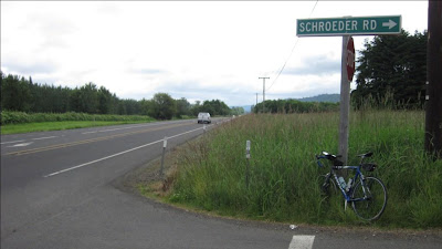
A Schroeder Road sighting on Day 1!

The route today was an easy one to follow. Even I couldn't get lost.  Make a left out of last night's hotel on to US30, cycle 69 miles and make a right into today's hotel.  There were two decent climbs, which I needed in order to shake the cobwebs out of my legs. (Actually, I worked a bit and was glad to see today's hotel.)  After being off the bike for a week, it takes a day or so to get your legs back. Several views of the Columbia River, and we passed a road named Schroeder!  Views of Mt. Hood should open up tomorrow as we get to and go through Portland. There is a lot of logging in the area and the logging trucks do not slow down when they go past you.  So one needs to be vigilant of traffic, though that is difficult to remember to do for several hours straight. After a while, you go brain dead when you get tired. Everyone is safely in for the day though. Tomorrow's ride to Welches will be on familiar streets for me.

Sunday, June 20, 2010

Day 0 - Pacific Ocean to Astoria

Today : 30 miles 782 feet of climbing


Arrival at the Pacific Ocean to dip our wheels


The beginning

We did ride this morning.  Today was the unofficial start of the ride, out to the Pacific Ocean and back.  I joined a group of about 15 riders at 10:30AM and we headed out to the coast for the traditional wheel dip in the ocean.  Low 50's with a few brief sprinkles of rain were ideal for a short easy first day.  Actually, today was called "day zero" so I guess the mileage didn't count. Am I really here? After snapping some pictures we headed back to the hotel with a stop at Fort Clatsop.  This is where Louis and Clark spent their second winter on their three year expedition.  The fort was not very large, more like a barracks than a fort, and conditions must have been tight for the men. At least the local Indians were friendly here.

Joe at Fort Clatsop
There are 54 riders and a staff of six on the ride.  Riders are from every part of the country plus Toronto, Switzerland, Scotland, and Hong Kong.  47 riders are going to the Atlantic and the other seven are just doing a section or two.  Later, we will pick up other riders doing latter sections.  Some of these section riders are completing the whole coast to coast ride over several years.  That is perseverance.

Tomorrow we head east, 69 miles to St. Helens.

Astoria


After a nice flight from Atlanta to Portland, and a two and a half hour bus trip from Union Station to Astoria, I'm at the start of the ride in Astoria.


The train and bus station in Portland

Registration and bike assembly is today, followed by a meet and greet, orientation, and dinner. Then, the ride starts tomorrow. Temperatures in the low 50's and rain today; a little bit different from what I am accustomed to in north Georgia. Never the less, I'm looking forward to meeting the other riders and getting my bike put back together today so I can start riding east.


The bridge from Astoria to the State of Washington

Sunday, June 13, 2010

Bicycle Ride Across Georgia


I just got back from a nice week long ride with my friends Gary, Harold, and Bill. This year's BRAG ride was a loop from Fayetteville down to Columbus and back. Seven days, 506 humid miles, and 24,000 feet of climbing, including Wednesday's century ride and all of the extra hammerhead options. I only see Harold and Gary one week per year for BRAG, but we pick up right where we left off the prior year. I appreciate them putting up with me for the week.


This was a good final tuneup for the cross country ride, both for me and the bike. The bike is ready to go after the overhaul by Dan at Free-Flite.  Tomorrow it will be dropped off at FedEx in Jasper after being boxed up at the bike shop. Then, I have an early morning flight to PDX on Saturday. I felt great during each day's ride this week, even towards the end of Tuesday's 82 miles and Wednesday's 104 miles.


I did meet someone on BRAG who did the cross country ride with ABB two years ago and got some good pointers from him. So all that remains is to pack my bag and laptop and fly out west where, hopefully, my bike will be waiting. Next post should be from Astoria.